translate

Showing posts with label basic of petroleum system. Show all posts

January 14, 2012

Free download e-journal : The Petroleum System: From Source to Trap (AAPG Memoir No. 60) by Lagoon & Dow

Free download e-journal : The Petroleum System: From Source to Trap (AAPG Memoir No. 60) by Lagoon & Dow

It can be downloaded HERE
Archive Password : ebooksclub.org


Keywords :  The Petroleum System: From Source to Trap (AAPG Memoir No. 60) by Lagoon & Dow, AAPG Memoir 60, Forearc basin, accretionary prism. 

December 24, 2011

SEDIMENTARY BASINS and THEIR TECTONIC SETTINGS

We now recognize that the origin of sedimentary basins is related in some way to
crustal movements and plate-tectonics processes.

Tectonic Settings

Divergent Settings


Terrestrial rift valleys : Rifts within continental crust commonly associated with
bimodal volcanism.
Modern example: Rio Grand Rift (New Mexico).

Proto-oceanic rift troughs : Incipient oceanic basins floored by new oceanic crust and flanked by young rifted continental margins.
Modern example: Red Sea.


Intraplate Settings

Continental rises and terraces : Mature rifted continental margins in intraplate settings
at continental-oceanic interfaces.
Modern example: East coast of USA.

Continental embankments : Progradational sediment wedges constructed off edges
of rifted continental margins.
Modern example: Mississippi Gulf Coast.

Intracratonic basins : Broad cratonic basins floored by fossil rifts in axial zones.
Modern example: Chad Basin (Africa).

Continental platforms : Stable cratons covered with thin and laterally extensive sedimentary strata.
Modern example: Barents Sea (Asia)
.
Active ocean basins: Basins floored by oceanic crust formed at divergent plate
boundaries unrelated to arc-trench systems (spreading still active).
Modern example: Pacific Ocean.

Oceanic islands, aseismic ridges and plateaus: Sedimentary aprons and platforms formed in
intraoceanic settings other than magmatic arcs.
Modem example: Emperor-Hawaii seamounts

Dormant ocean basins: Basins floored b y oceanic crust, which i s neither spreading nor subducting (no active plate boundaries within or adjoining basin).
Modem example: Gulf of Mexico.


Convergent Settings

Trenches: Deep troughs formed by subduction of oceanic lithosphere.
Modem example: Chile Trench.

Trench-slope basins: Local structural depressions developed on subduction complexes.
Modem example: Central America Trench.

Fore-arc basins: Basins within arc-trench gaps.
Modern example: Sumatra.

 Intra-arc basins : Basins along arc platform, which includes superposed
and overlapping volcanoes.
Modern example: Lago de Nicaragua.

Back-arc basins: Oceanic basins behind intraoceanic magmatic arcs
(including interarc basins between active and remnant
arcs), and continental basins behind continental-margin
magmatic arcs without foreland fold-thrust belts.
Modern example: Marianas.

Retro-arc foreland basins: Foreland basins on continental sides of continental-margin arc-trench systems (formed by subduction-generated compression and/ or collision).
Modern example: Andes foothills.

Remnant ocean basins: Shrinking ocean basins caught between colliding continental margins and/ or arc-trench systems, and ultimately subducted or deformed within suture belts.
Modern example: Bay of Bengal.

Peripheral foreland basins: Foreland basins above rifted continental margins that have been pulled into subduction zones during crustal collisions (primary type of collision-related forelands).
Modern example: Persian Gulf.

Piggyback basins: Basins formed and carried atop moving thrust sheets.
Modern example: Peshawar Basin (Pakistan).

 Foreland intermontane basins : (broken forelands): Basins formed among basement-cored uplifts in foreland settings. Modern example: Sierras Pampeanas basins (Argentina).


Transform Settings


Transtensional basins: Basins formed by extension along strike-slip fault systems.
Modern example: Salton Sea (California).

Transpressional basins: Basins formed by compression along strike-slip fault systems.
Modern example: Santa Barbara Basin (California) (foreland).

Transrotational basins: Basins formed by rotation of crustal blocks about vertical axes within strike-slip fault systems.
Modern example: Western Aleutian fore-arc (?).


Hybrid Settings

Intracontinental wrench basins: Diverse basins formed within and on continental crust owing to distant collisional processes.
Modern example: Quaidam Basin (China).

Aulacogens: Former failed rifts at high angles to continental margins, which have been reactivated during convergent tectonics, so that they are at high angles to orogenic belts.
Modern example: Mississippi Embayment.


Impactogens: Rifts formed at high angles to orogenic belts, without preorogenic history (in contrast with aulacogens).
Modern example: Baikal Rift (Siberia) (distal).

Successor basins: Basins formed in intermontane following cessation of local orogenic or taphrogenic activity.
Modern example: Southern Basin and Range (Arizona).


Keywords : basins, sedimentary basins, basin classification, tectonic basin, rift, compressional basin


Refference : Boggs Jr, Sam. 2006. Principles Of Sedimentology And Stratigraphy 4th Edition. Pearson Education, Inc. New Jersey.

December 5, 2011

Petroleum System

Preface

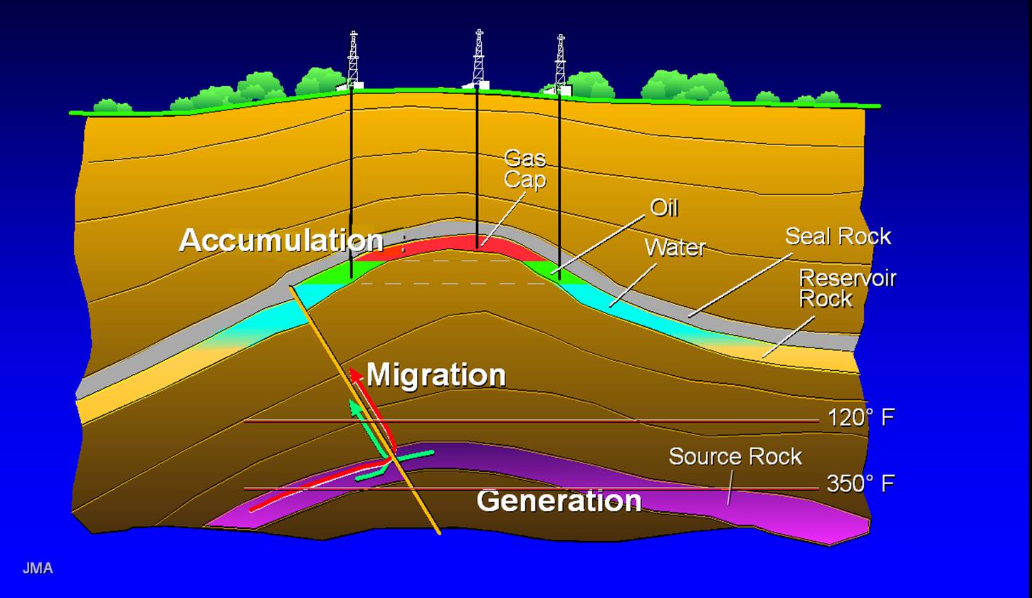
Petroleum system consist of source rock, reservoir, seal/cap rock, trap, migration, and maturity.

a. Source rock : Source of the oil, usually limestone and shale. Source rock has many organic material from reefs, planctonic, etc.
b. Reservoir : porous and permeable lithological unit or set of units that holds the hydrocarbon reserves. Analysis of reservoirs at the simplest level requires an assessment of their porosity (to calculate the volume of in situ hydrocarbons) and their permeability (to calculate how easily hydrocarbons will flow out of them).
c. Cap Rock : unit with low permeability that impedes the escape of hydrocarbons from the reservoir rock. Common seals include evaporites, chalks and shales. Analysis of seals involves assessment of their thickness and extent, such that their effectiveness can be quantified
d. Trap : trap is the stratigraphic or structural feature that ensures the juxtaposition of reservoir and seal such that hydrocarbons remain trapped in the subsurface, rather than escaping (due to their natural buoyancy) and being lost.
e. Migration : oil moves from source rock, then fill in reservoir pore and trapped
f. maturity : to make predictions of the amount and timing of hydrocarbon generation and expulsion

http://smiatmiundip.files.wordpress.com/2011/05/migrasi.jpg

Mechanism (of the figure)

Source rock which has organic material (planctonic, algae, etc) produce the oil because the temperature make it mature. Then the oil moves into reservoir through the fault and fill the pore (migration). Then after the migration happens, it will be trapped and accumulated. The density of oil < density of water, accordingly oil always on the top of the water. When the oil reach the specific point, it will be gas.

Why the oil/gas not leak to the surface?
Because the top of reservoir rock, there are seals rock. Seal consist of impermeable rock, usually claystone. and the top of seal named overburden rock.

Trap
There are kinds of oil/gas trap

Structural Trap : formed by a deformation in the rock layer that contains the hydrocarbons. There are salt dome, fold, and fault trap. Structural traps are the easiest to locate by surface and subsurface geological and geophysical studies. They are the most numerous among traps and have received a greater amount of attention in the search for oil than all other types of traps.
  1.   Salt Dome Trap : Intrusion of salt because of differential density of rock layer and salt. Salt will tends cut the top layer on it. Then, it makes a trap for oil accumulation.                                                                http://www.cartografareilpresente.org/local/cache-vignettes/L300xH232/Salt_dome_trap-42877.jpg
  2. Fold Trap : Compression of tectonics make rock layers folded and forms sincline and anticline. Anticline is the best trap, because the drilling process is relatively easy. The oil and gas move to the top because pressure, and drilling started on the topper of anticline because of eficiency height.                                                                            

         3. Fault Trap : Trap formed by fault (look at the figure on top), and the oil could not to moves because                 there was impermeable layer

Stratigraphic Trap : formed when other beds seal a reservoir bed or when the permeability changes (facies change) within the reservoir bed itself. Stratigraphic traps can form against either younger or older time surfaces.

Source :
http://en.wikipedia.org/wiki/Petroleum_geology
http://en.wikipedia.org/wiki/Petroleum_reservoir

keywords : Petroleum system, trap, reservoir, source rock, structural trap, seal rock, petroleum geology, migration, fault

December 3, 2011

Sedimentology in sedimentary basin : Fore-arc Basin

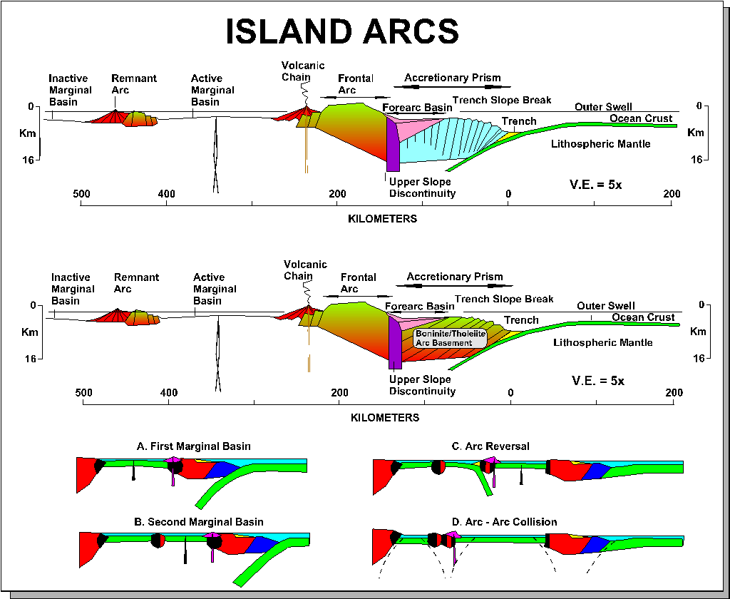
Along destructive margins, fore-arc refers to linear areas seaward of continental or oceanic volcanic arcs and landwards of any accretionary prism or trench .


A subsiding forearc referred to as a fore-arc basin, rooted in either modified continental or oceanic crust. Bathymetrically, fore-arcs are rather variable. Most are shelf-like, with gentle slopes up to 100 km or more wide. Some are much more complex, with a plethora of sub-basins and local uplifted highs associated  with both thrust and normal faulting. They act as sediment traps for the often prodigious sediment fluxes issuing from adjacent volcanic arcs. Volcanic airfalls, submarine slumps and eruption-driven  turbidity currents transfer sediment downlope. Floating pumice rafts disperse more widely over the destructive margin. The efficiency of the fore-arc trap increases as ridge-like barriers form by accretionary offscrapping at the trench-slope break. The tendency with time is for the initially  shallow fore-arc, with its coarse-grained basal deposits, to deepen quickly and then to infill gradually with a coarsening-upwards, predominantly turbiditic facies of arc volcanic provenance.

With time, the fore arc broadens and shallow by sediment onlap both oceanwards and landwards. The end result is an increasingly inefficient trap configuration. Basin fills from cainozoic and mesozoic example may reach up to 10km in thickness. The grat basin of california is perhaps the best exposed and investigated example of an ancient fore arc, whilst amongst active examples the sumatera-java fore-arc shows many classic features.

In order to understand how many fore arc basin originate as residual features superimposed upon older oceanic or continental-margin basement, it is necessary to conduct a thought experiment by imagining the likely sequence of events when subduction is initiated along a passive continental margin. During such a process, oceanic slab failure and reversely buoyant descent will occur oceanwards  of the last thinned  or modified continental crust. Fore-arcs are thus underlain by oceanic, modified oceanic or thinned continental crust, and bounded oceanwards by the first offscraped sediment of the nascent accretionary prism. Water depth are initially deep, liable to rapid infill by copious sediment flux from the adjacent arc.
Sediment loading induces extra flexural subsidence around the basin margin, causing forebulges, then waves of subsidence to migrate outwards towards both the trench-slope break and the volcanic arc, causing progressive onlap on those features. Fore-arc terrains along periodically extensional destructional margins undergo alternating uplift due to shortenng and subsidence as the area of the whole trench-arc gap episodically increases due to stretching.

Source : Leeder, Mike.1999.Sedimentology and Sedimentary Basins (From Turbulence to Tectonics). Blackwell Publishing. Malden (USA). page 520

keywords : Fore-arc basin, sedimentary basin, arc, sedimentology fore-arc

November 22, 2011

Basic of Evaluation Concepts : Properties of Rock for Log Analyzing


Logging provides data needed to evaluate the quantity of hydrocarbon in the coating on the actual situation.  Curves log provide data on the properties of rocks and fluids.

Rock properties that are important to analyze the logs are porosity, water saturation, permeability. The first two parameters can be calculated quantity of hydrocarbons in the layer, and the last parameter indicate where the hydrocarbon can be produced.

Porosity
Porosity is Part of the Total volume of porous rocks. In unconsolidated formation, number of porosity depends on grain size distribution. If all grain have a similar size, porosity will be able on number 0,35-0,4 (high). But, it will be lower if grains have variative size, because the small grain able to fill in space between larger grain.


Water Saturation
Water Saturation is Part of porous space filled with water (Sw). Residual part of water saturation named hydrocarbon saturation (Sh). Sh = 1 - Sw. The main purpose from logging operation is for this, make calculating saturation of water and hydrocarbon


Permeability
Permeability is ability of rocks to pass the fluids. Permeability depends on grain size of sedimentary rocks. Sediment with large grain size and large pore has high permeability number, and the opposite. 


Hydrocarbon-Bearing Rocks
Generally consist of sandstone, limestone, and dolomit.

Sand can moved and deposited by water. The more swift water flow, more coarse grain. Therefore the sand tends to have a similar porosity between of it's grains.

Limestone isn't like sand, it will be deposited by seawater movement. A few part solute deposit, and the other part is heaps of organic remains. Porosity of limestone is less similar than sandstone.

Dolomit is built when water rich of magnesium flow on limestone, and change few calcium with magnesium. Dolomitization is important mechanism to avail pore space for hydrocarbon accumulation.


Clays and Shales
Clays are main component of sedimentary rock. There are montmorillonite, illite, chlorite, and kaolinite.
Shales are composed from clays and silts ( soft silicates) that deposited by low energy sedimentation.
The permeability of shales is 0. Shales and Clays make Hydrocarbon Formation analyzing be difficult. You have to know log interpretation on clean formation, then analyzing dirty formation.


Article Basic of Evaluation Concepts : Properties of Rock for Log Analyzing is free in thi blog.
Source : Harsono,Adi.1994. Pengantar Evaluasi Log.

November 15, 2011

Log Evaluation : Preface

PREFACE

Measurement in well log can divided into 4 categories :

  1. Drilling Operation Log : mud logs, MWD (Measurement While Drilling), LWD (Logging While Drilling)
  2. Core Analyze
  3. Well log with wireline : electric, accoustic, radioactive, electromagnetic
  4. layer production test
Because of technically or economically, not all of measurements applicated in each well. For example, picking up core and LWD system need huge cost than others.

The main purpose of formation evaluation are :
  1. Identify reservoir
  2. Estimate hydrocarbon reserves
  3. Estimate hydrocarbon gains

LOGGING PROCESS

In exploration wells, It's important to gain information as much as possible continuously, in order to obtain a better observation of geological structure to correlating with the others well while oil field is on developing.

It's easily achieved with logging operation on openholes that started from maximum depth (TD) in to casing shoe. Do logging at short interval to avoid opennes formation layers toward mud system.

Logging operations have to done as fast as possible, but datas quality is more important. On final logging operation in Total Depth, important decisions will made based on logging, and it is determine the fate of well. And then you have to make some interpretations manually or with computer named Field Log Interpretation center (FLIC).

Log Evaluation : Preface - Source : Harsono, Adi. 1994. Pengantar Evaluasi Log. Jakarta

October 7, 2011

Drilling

Drilling

A. preface
In hydrocarbon exploration activities, is known several types of drilling which are difference by the purpose. There are :
1. Stratigraphic Drilling
2. Structure Drilling
3. Seismic Operation Drilling
4. Exploration Drilling
5. Production Drilling
Exploration Drilling is the most important thing for wellsite geologist.

B. Drilling Tools
Drilling implemented by many tools as known as drilling rig. Rig's type is divided based on by the place that built in, there are onshore rig and offshore rig.


Almost onshore rig have same type, but offshore rig have 5 big types which designed for each specific condition.
there are : barge, jack-up, fixed platform, semi-submersible and drillship.
1. Main Components of Rig
     A. Rotaring System : to rotate Kelly pipe which the bottom is connected with drillstring and bit  which can spin too.
     1.1 Bit : is point of drill, for drilling
      1.2 Bit sub : one of bit series
      1.3 Drill Collars : give more weight to bit, so drill pipe can stay straight if it pressed.
      1.4 Drillpipe : or steel pipe, as a drilling tube  on drilling system.
      1.5 Kelly saver sub
      1.6 Kelly
      1.7 Swivel
      1.8 Rotary
      1.9 Prime movers and compound
      1.10 Kelly bushing

B. Circulating System
       Circulatinng System help the rotary system while drilling and renew drilling fluid in hole. It consist of :
       1. Bit sub
       2. Drill Colars
       3. Drillpipe
       4. Rotary house and standpipe,
       5. Blow out preventer

C. Hoisting System
        To put down / lift drillpipe series from well, have a role while drilling and while connection and tripping out. It consist of :
        1. Hook
        2. Travelling Block
        3. Wireline
        4. Crown Block
        5. Drawn works
        6. Prime movers and compound
        7. Derrick
        8. Flare bridge
        9. Module
        10. Racking Platform
        11. helipad

Source : Assistants, Staff., 2011, Panduan Praktikum Geologi Minyak dan Gas Bumi,Sedimentography Laboratory, Geological Engineering Department, Faculty of Engineering, Gadjah Mada University, Yogyakarta, Indonesia.